
Drone Surveys Oxford & Oxfordshire
Drone Surveys & Drone Inspections in Oxford & Surrounding Areas
Global Drone Surveys delivers CAA-licensed drone surveys in Oxfordshire, supporting clients across Oxford, Abingdon, Didcot, Bicester, Witney, Banbury, Wantage and the wider Thames Valley. We help construction teams, estates managers and consultants capture accurate site information quickly—without the delay and disruption of traditional access methods.
Where we’re typically deployed around Oxford:
-
Commercial roofs and multi-building estates
-
Live construction sites and refurbishment projects
-
Industrial units, logistics parks and business estates
-
Schools, colleges and public sector buildings
-
Heritage and sensitive buildings requiring careful access planning
Typical Oxford Work We Support
Oxford and the surrounding towns include everything from listed heritage property and historic estates to modern science parks and business campuses. Our drone surveys provide clear, high-resolution visual evidence to support maintenance planning, reporting and project decisions—without unnecessary disruption.
Common use cases in Oxfordshire:
-
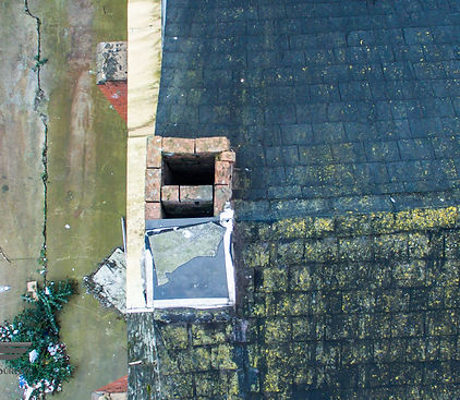
Listed & historic building surveys heritage roofs, stonework, towers, chimneys and hard-to-reach details
-
Roof condition surveys tile, slate and flat roofs, gutters, flashings, parapets
-
Asset inspections façades, spires, chimneys, plant areas, PV arrays
-
Construction progress flights for programme reviews, stakeholder updates and documentation
-
Thermal imaging surveys to help identify heat loss and potential moisture issues scope dependent
-
Mapping & photogrammetry for planning, measurement and records project dependent
What You Receive (Deliverables)
You won’t just get a folder of photos—deliverables are structured so your team can act on them quickly.
Typical outputs include:
-
High-resolution inspection imagery organised by area/elevation
-
Annotated key findings (if requested) to support reporting and actions
-
4K video clips for visual review and stakeholder updates
-
Repeatable capture for before/after comparisons and ongoing monitoring
-
Mapping/3D outputs where required (orthomosaic / model—project dependent)
Construction time-lapse services in Oxford
We also provide construction time-lapse services in Oxford and Oxfordshire, installing long-term, weatherproof cameras to capture clear progress from start to finish. It’s ideal for live builds, stakeholder updates and creating a reliable visual record of key milestones.
Oxford time-lapse is ideal for:
-
Progress reporting and programme reviews
-
Client, investor and stakeholder updates
-
Marketing, PR and handover documentation
-
Capturing phased works and key project milestones


Oxford Roof Surveys (Fast, Low Disruption)
Roof access can be slow, expensive and disruptive. Drone roof inspections provide fast visibility across large areas—ideal for estates and multi-building sites.
Roof survey benefits:
-
Reduce the need for scaffolding or MEWPs during early assessment
-
Identify defects early (cracked tiles, failed flashings, blocked gutters)
-
Provide a clear visual record for consultants and maintenance teams
-
Support tendering and budgeting with evidence-led decision making

Working with Drones in Oxford Airspace
Oxford and the surrounding area can include sensitive or controlled airspace considerations, so every UAV job starts with careful planning to ensure the survey is carried out safely, legally and with minimal disruption. If additional coordination or permissions are required for your site, we manage the process and confirm realistic lead-in times before mobilisation.
Before every Oxford flight we:
-
Check NOTAMs and temporary restrictions
-
Review up-to-date aviation charts and local operational constraints
-
Confirm safe take-off/landing areas and agree site boundaries with the client
-
Complete documented risk assessments and safe systems of work
-
Arrange any required coordination/permissions and keep you informed on timeline
Safety-Led Delivery (Experience You Can Rely On)
Our operations are built around disciplined, safety-first delivery. We’re used to working on live sites where coordination, clear boundaries and controlled capture matter.
How we keep sites safe and compliant:
-
Pre-site planning with clear scope, outputs and capture method
-
Practical coordination with site teams (inductions, safe zones, time windows)
-
Risk-based operating approach designed to minimise disruption to your site
-
Experienced pilots with a strong track record of safe operations
-
Clear communication before, during and after the flight so everyone knows what to expect

FAQs – Drone Surveys Oxford & Oxfordshire
Can you survey listed and historic buildings in Oxford?
Yes. We regularly support inspections on heritage and listed properties, capturing high-resolution imagery of roofs, chimneys, parapets and elevated features while keeping site disruption to a minimum. Deliverables are organised so consultants can reference locations quickly.
Do you work on colleges, estates and multi-building sites around Oxford?
We do. Oxford often involves campuses and multi-building estates, so we can plan surveys to cover multiple roofs/assets in one visit and deliver outputs grouped by building, elevation and priority areas.
What’s the difference between a drone inspection and a measured survey?
A drone inspection focuses on visual condition and evidence (images/video for defects and reporting). A measured survey adds mapping/photogrammetry outputs (project dependent), such as orthomosaics or 3D models, which can support measurement, planning and documentation.
Can you provide repeat surveys to track change over time?
Yes. We offer repeat inspections (monthly/quarterly/annual) using consistent capture positions where possible. This is useful for maintenance programmes, post-repair verification and tracking gradual deterioration on roofs and façades.
How do you handle Oxford airspace and site constraints?
Every job starts with structured planning. We check current restrictions, review the site environment, and coordinate the safest operating areas and timings with your site contact. If any additional permissions or coordination are required, we manage the process and advise lead-in times.
What do you need from us to quote an Oxford drone survey?
A postcode or site pin, what you want surveyed (roof/façade/asset/mapping/progress), approximate building size/count, and the deliverables you need (images only vs mapping/3D). We’ll confirm scope, timeline and price clearly.
Can you inspect roof-mounted plant and gutters effectively?
Yes. Drones are well suited to checking gutters, parapets, roof junctions and rooftop plant areas—especially where access is difficult or where you want an early-stage assessment before arranging high-level access.
Do you provide outputs suitable for reports and stakeholder updates?
Yes. Deliverables are supplied in a clean structure for easy reporting, with high-resolution images and optional 4K video. For projects that need regular updates, we can also provide repeat progress packs.
What areas do you cover besides Oxford?
We cover Oxford and the wider county, including Abingdon, Didcot, Bicester, Witney, Banbury, Wantage and Wallingford, plus surrounding areas for cross-county projects.
How quickly can you deliver results?
Turnaround depends on site size and outputs, but we aim for prompt delivery and will agree a realistic timeframe at quotation stage—especially for time-sensitive inspections or live projects.

DRONE FILMING AERIAL FILMING OXFORD

Whether you’re a TV production looking for a professional, adaptive and fully kitted out drone crew, you simply want to consult on what an unmanned aerial vehicle could add to your production, or you’d like to discuss a full production corporate package for your event, company or brand, give us a call and we’d love to chat!
DRONE MAPPING AND PHOTOGRAMMETRY OXFORD

Online satellite imagery can be out-dated by up to 6 years and can be unreliable in planning and analysis needs. Drone survey imagery is typically 20 times the resolution of Google Earth, allowing for greater planning detail and when augmented by our 3D mapping capability, provides ground representation to the smallest detail.