Drone Mapping for Surveys
Drone mapping uses UAVs to capture structured aerial imagery over a site, which is then processed into accurate, geo-referenced outputs. Photogrammetry is the processing method that converts overlapping images into measurable products such as orthomosaics, 3D models and surface representations.
For project teams, this provides a fast, safe way to document site conditions, support planning decisions and create repeatable datasets for progress comparisons—without the disruption of traditional access methods.
What You Receive (Deliverables)
Deliverables are confirmed at quote stage and supplied in an organised, easy-to-review format. Depending on your scope, outputs may include:
-
Geo-referenced aerial imagery for reporting and documentation
-
Orthomosaic mapping (high-detail stitched site map)
-
3D photogrammetry models for visualisation and review
-
Surface representations to support measurement and site understanding (scope dependent)
-
Progress comparison datasets for repeat flights and milestone reporting
-
Project-ready files supplied in agreed formats (subject to requirements)
If you tell us what your team needs to do with the data (planning, reporting, measurement, stakeholder updates), we’ll recommend the most suitable deliverables.


Typical Use Cases (Construction, Infrastructure, Planning)
Our drone mapping and photogrammetry services are commonly used for:
Construction
-
Site overviews for programme reporting and stakeholder updates
-
Progress capture at key milestones using repeatable flight plans
-
Baseline “pre-works” site condition records for project teams
Infrastructure
-
Corridor and asset context capture to support planning and maintenance teams
-
Visual documentation of complex sites where access is restricted or high-risk
-
Repeat mapping to monitor change over time (project dependent)
Planning and Development
-
High-resolution site imagery for planning documentation and presentations
-
Clear visuals for stakeholder engagement and project communications
-
Site context capture to support early-stage feasibility work
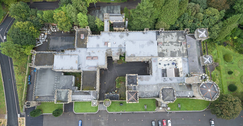
Zoom into the map over the castle to see the difference in resolution of online satellite mapping compared to the our drone produced mapping. Best viewed on a PC.

How We Deliver Mapping Projects (Capture → Processing → QA → Delivery)
We follow a structured workflow to ensure consistent outputs and a smooth client experience:
Capture
We confirm objectives, deliverables and site constraints, complete airspace and site checks, and plan an efficient flight pattern to collect the required dataset.
Processing
Imagery is processed using professional photogrammetry workflows to generate the agreed outputs, maintaining consistency across the dataset.
Quality Assurance
We review the outputs for completeness and clarity, ensuring deliverables align with the project brief and intended use.
Delivery
Files are provided via secure transfer in an organised package, with clear naming and supporting notes where required—making it easy for your team to review and share internally.
FAQs: Drone Mapping & Photogrammetry
How much does drone mapping cost in the UK?
Cost depends on site size, location, airspace constraints, deliverables required and processing time. Share a postcode (or pin) and your objectives and we’ll provide a clear quote.
What’s the difference between drone mapping and photogrammetry?
Drone mapping refers to collecting structured aerial data over a site. Photogrammetry is the process used to convert overlapping images into measurable outputs such as orthomosaics and 3D models.
How long does a mapping project take?
Timescales vary by site size, permissions and deliverables. We’ll confirm mobilisation and delivery timelines during quoting.
What information do you need to quote?
A site location, approximate site size, your intended use (planning, reporting, measurement), and the outputs you want. Drawings or a short brief help us quote accurately.
Can you repeat flights to track progress over time?
Yes of coarse . We can schedule repeatable capture at agreed intervals to provide consistent progress updates and change comparison.
Do you operate in controlled or restricted airspace?
Where feasible, yes. We plan each job carefully and manage required permissions and coordination where applicable.
What formats can you deliver?
We supply outputs in agreed formats based on your workflow and requirements. Tell us how your team will use the data and we’ll confirm the most suitable deliverables.Coomon formates we use :
Core map / orthomosaic outputs
-
JPG exports for 2D layers (with georeferencing sidecar files like KML + TWF).
-
GeoTIFF exports for 2D layers (GIS-ready; includes TWF and sometimes KML depending on projection).
-
PDF exports of 2D / Elevation / DTM / Plant Health layers (useful for sharing).
Elevation / terrain outputs
-
GeoTIFF DEM (raw elevation values) for Elevation and Digital Terrain Model exports.
-
Contours as DXF (CAD) or SHP (GIS).
3D / point cloud outputs
-
3D model (OBJ) with texture JPGs (note: DroneDeploy states the OBJ export is not georeferenced and uses a model-local coordinate system).
-
Point cloud exports:
-
LAS
-
XYZ (XYZRGB)
-
RCP (Autodesk ReCap format; Enterprise).
-
Other useful exports
-
Source imagery (ZIP) (Enterprise).
-
Annotations export as GeoJSON (handy for GIS workflows).
-
Annotation Report (printable record of measurements/annotations for inspections, stockpiles, progress updates).
-
Is drone mapping suitable for every site?
Most sites are suitable, but constraints such as airspace restrictions, weather, access and the required outputs can affect feasibility. We’ll advise the best approach once we review your location and scope.
What can Drone Mapping be used for ?
Drone mapping and photogrammetry has number of uses and offers real efficies over trational data collection methods below are some examples of where this is being used to save time and money.
-
Drone Remote sensing and photogrammetry
-
Drone & mapping of earthquakes
-
Surveying & mapping of plane crashes
-
Surveying & mapping of storms and hurricanes
-
Tidal mapping
-
Drone Mapping of industrial zones
-
UAV Mapping of excavation sites
-
Surveying & mapping of flooding
-
Surveying & mapping of train crashes
-
Photogrammetry
-
Drone Mapping of the spread of algae
-
Forestry surveying
-
UAV Mapping of Vegetation
-
Mapping sandbar measurements
-
Precision agriculture
-
Surveying & mapping of landslides
-
Surveying & mapping of tsunamis
-
Agriculture - GIS applications
-
Arctic research - surveying
-
Geophysical mapping
-
Drone Mapping of coastal areas
-
Surveying & mapping of catastrophes
-
UAV Surveying & mapping of mudslides
-
Surveying & mapping of volcanic eruptions
-
Drone Agriculture – mapping plant growth
-
Mapping shifts in sandbars
Elevation Mapping
Accurate geo-referenced elevation maps and contour maps including DTM.
These can also be produced with measuring tools which allow for the measuring of earthworks, spoil piles, and stock-taking, with outputs in either metric or imperial.
This provides our clients with fantastic easy to use tools for taking large volume measurements on site, saving both time and money.
Again we can supply these mapping solutions in a number of outputs including web-based with measuring tools and annotations attached for ease of use.

3D Geo Referanced Photogrammetry Models
The photogrammetry 3D models below are interactive and best viewed on a PC or Laptop, these are low-resolution examples for web use. You are able to scroll through the images and turn them as you please. If you would like any more details of how we can help your business or project with our aerial mapping services please don’t hesitate to contact us


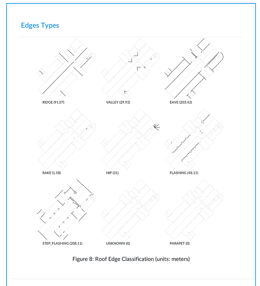
Geo-Referenced Drone Survey Roof Reports
The roofing, insurance, and solar industries are undergoing a fundamental change in the way they operate. No longer do you have to spend valuable time manually inspecting roofs to process insurance claims, detect damage, or plan and design solar array installation. Global Drone Surveys use the latest technology that allows our roof inspectors to save time, increase productivity, and improve worker safety by using drones for roof inspection measurements and drone roof reports. contact us for further details